
Like many, I picked up hiking in 2021 when we were still isolated during COVID. The time outdoors was a great way to disconnect, enjoy nature and get the daily dose of exercise in. Since then, I’ve been fortunate to hike 1,000 miles (okay, technically 991.5 miles, but I think rounding up is justified here) on 250 trails, spending 388 hours outside and climbing 170,000 feet. Those stats do make this hiking hobby sound a bit miserable, but it’s provided so many opportunities to see places you simply can’t from a car. So without further ado, here are my favorite ten day hikes in the US*.
*To be considered hikes had to be at least three miles and in the United States, and I weighted both the hike itself and the views to create the list. I’ll try to keep this list updated over time as hikes fall in and out of the top 10.
1. Grinnell Glacier Trail, Montana
Mountains, waterfalls, wildlife, streams, wildflowers, lakes, a glacier…what makes this trail so spectacular is how much of the jaw-dropping flora and fauna of northern Montana you’ll see.
The trail starts in a large parking lot before quickly hugging the shores of Swiftcurrent Lake and Lake Josephine. The elevation gain is minimal, but the views start nearly instantly as numerous towering mountains appear around all sides of the trail.
The trail quickly begins steadily climbing at the two mile mark with a short reprieve before a steep one mile climb at the end. The journey up isn’t particularly technical nor challenging, but the distance, altitude and heat can make it difficult, especially if you’re not an avid hiker.
As you climb, you’ll pass Grinnell Lake, a spectacularly brilliant turquoise-blue gem surrounded by lush, green forests and rocky, towering mountains. It’s the contrasts that make this hike so otherworldly and jaw-dropping.

You’re likely to pass quite a bit of wildlife around this portion of the trail; the park is home to 71 mammals, including grizzly bears, mountain goats and mountain sheep. Our first animal sighting of the hike was a grizzly bear strolling down the trail; it was quite the scene as dozens of hikers ran down the mountain while the bear ambled about, clearly not interested in any human activity. Fortunately, he left the trail and we proceeded with the hike (bear spray in hand), passing a family of mountain goats resting on a precipitously steep cliff.


The top of the hike features the (unfortunately quickly shrinking) namesake of the hike: Grinnell Glacier. The glacier is named after George Bird Grinnell, a conservationist in the late 19th and early 20th centuries. While not as impressive as it once was (it’s predicted that the glacier–along with all other glaciers in the park–will be gone by the end of this century), it’s a unique and marvelous spot to take in the scenery before the trek down.

The hike down is potentially even more impressive as you gaze down upon the valley; it’s hard to put into words what this looked like in real life, which is why it earns the #1 spot on the list.


We reached the bottom of the hike as the sun fell below the mountains; the fading light led to some truly incredible photographs.


Grinnell Glacier belongs on every bucket list; it’s worth every second of time and effort spent traveling to this majestic point on our Earth.
Distance: 11 miles
Elevation Gain: 2,100 feet
Difficulty: Moderate (due to the length)
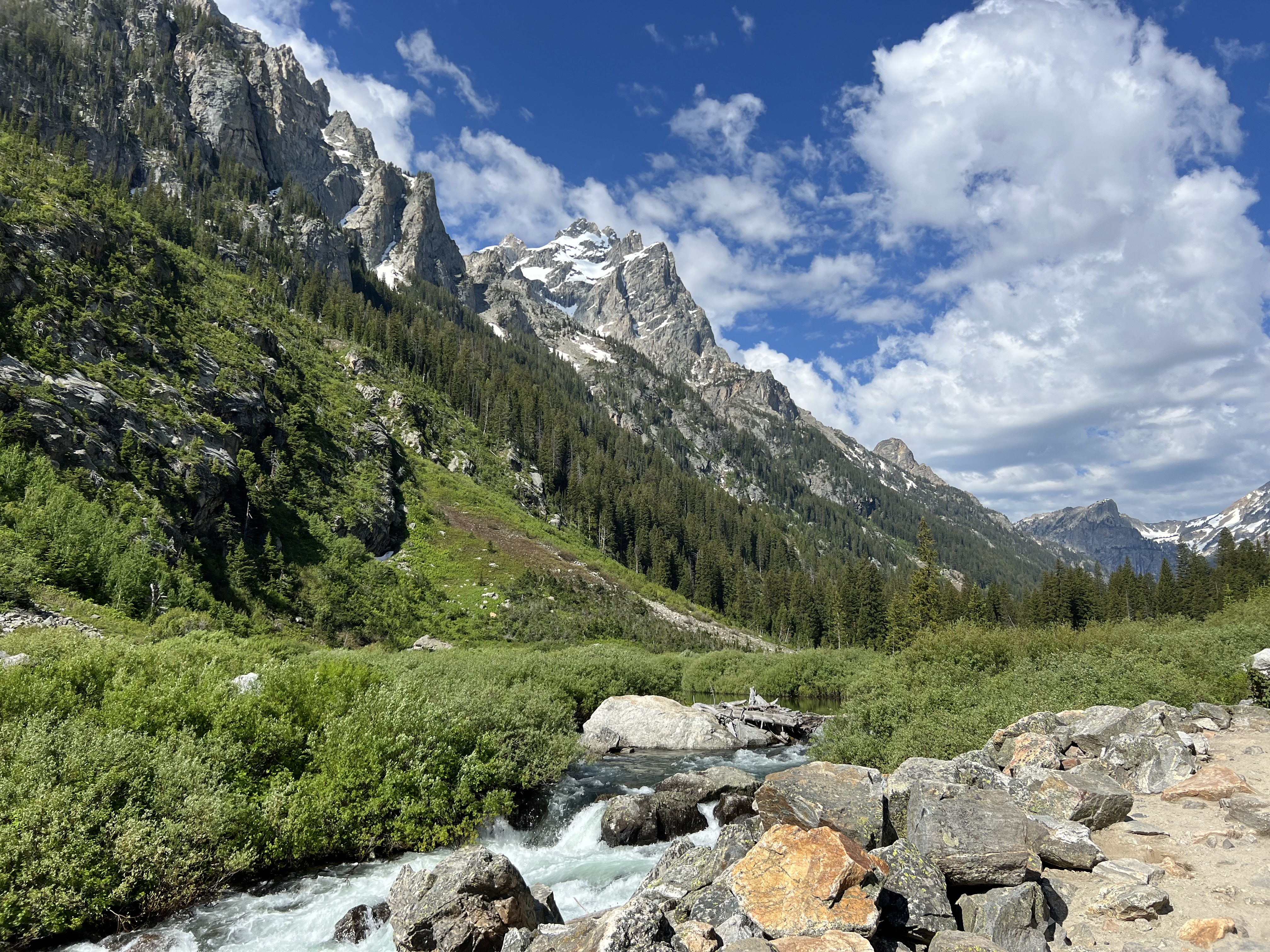
2. Cascade Canyon Trail, Wyoming
Cascade Canyon Trail finds its home in a glacial-built canyon in Grand Teton National Park. It’s a nine mile roundtrip including a shuttle boat ride (which you can skip, but tack on an additional two miles each way), a trip past Inspiration Point, a huge waterfall, and an unreal view of the Cathedral Group (Mount Owen, Teewinot Mountain and Grand Teton). This view is perhaps the best I’ve ever seen from the base of a mountain.
The hike starts with a shuttle boat ride across Jenny Lake; already, you’ll see the greys Cathedral Group towering over the deep-blue lake.

Unlike Grinnell Glacier, Cascade Canyon begins its climb immediately, eating up a third of the relatively modest 1,100 feet of elevation gain in the first mile and a half. Half a mile in, hikers reach Hidden Falls, and it’s around this point when the views of the surrounding mountians begin to get more impressive. The juxtaposition of the greens of the trees and grass, whites of the rushing water, greys of the mountains and blues of the sky is unlike anything I’ve experienced on any other hike (and to think you can experience it all within just half a mile of the trailhead!).


At three quarters of a mile in, the steepest hiking is done and you’ll reach Inspriation Point, which looks over Jenny Lake and Jackson Hole Valley to the east and the Teton Range to the west.


Just half a mile after, you’ll be inside Cascade Canyon where the trail continues for an additional four miles, gently sloping up as you meander through the canyon and next to Cascade Creek. The views inside the canyon are perhaps my favorite of any hike.


Wildlife is again abundant in Grand Teton, and although we didn’t see anything noteworthy up close, you could spot activity in the distance.
Because of the tame elevation gane and well-defined trail, it’s easy to knock this hike out in half a day, leaving time to drive around the park, explore Jackson, or even head to the airport for a late flight (what we did). Grand Teton’s proximity to the town and airport is unique in this part of the country and makes shorter trips easy and plenty worthwhile. It’s the perfect introdction to hiking longer distances and provides some of the most memorable hiking I’ve ever done.
Distance: 9 Miles
Elevation Gain: 1,100 feet
Difficulty: Easy to moderate (due to length)
3. Black Elk Peak and Little Devil’s Tower Loop, South Dakota
This is the first hike on this list where if you told me that it would make the list, let alone fall into third place, I probably would have laughed at you. But this hike has it all–views for miles, varied surroundings including mountains, rolling hills, and rock formations, a short section of scrambling, two noteworthy peaks and a CCC fire tower.
The hike starts in Custer State Park, where parking seems abundant on a satellite map but was in fact aggressively not abundant on the cool July morning I hiked. This combination trail is broken into three segments: the parking lot to Black Elk Peak (3 miles, 1,200 feet elevation gain), Black Elk Peak to Little Devil’s Tower (3 miles, 300 feet elevation gain including scrambling), and Little Devil’s Tower to the parking lot (2 miles, no elevation gain). It’s definitely worth doing it in this order so you tackle most of the elevation gain as you begin the hike.
The first section of the hike features two big climbs with a respite in the middle. Nothing is particularly technical, so hikers of nearly any age should be able to reach the top. The peak is a great spot for lunch as it offers a huge rocky outcropping, a large fire tower, and 360 degree views of the Black Hills.


After the peak, you’ll descend for two miles before reaching the spur trail to Little Devil’s Tower. The short detour picks up 200 feet of elevation in less than half a mile and includes some scrambling–a fun change of pace for an otherwise well-kept path clear of rock. At the summit, you’ll again have 360 degree views of the surrounding area including the nearby Cathedral Spires.


After scrambling down Little Devil’s, it’s a straight shot back to the parking lot as you pass through a bucolic meadow and continue to meander past stunning rock formations. This was an unexpectedly excellent hike that features some easy, some moderate and even some challenging along with great vistas, a fabulous spot for a picnic, and views of a spectacular part of the country.
Distance: 8 Miles
Elevation Gain: 1,700 feet
Difficulty: Moderate
4. Granite Lake/Maggie’s Peaks, California
Lake Tahoe at its finest! A quick four mile hike provides sweeping views of the deep-blue Lake Tahoe and surrounding mountains. It’s a great bang for your buck hike that stays fairly mild all summer long.
This is the shortest hike on the list thus far, and it’s a fairly straightforward four miles. The climb is steady and unrelenting, but you’re nearly immediately rewarded at the 0.5 mile mark with a stunning view of Emerald Bay.

It’s only another half-mile before reaching the (icy-cold) Granite Lake. Most folks cruised past the lake when we hiked, so we had the area to ourselves, a rarity on the otherwise heavily-trafficked trail.

The trail continues climbing, reaching the saddle of Maggie’s Peaks before beginning a very steep quarter-mile jaunt to the top trek. You’ll first reach the north peak; if you choose to walk an extra couple hundred feet, you’ll be treated to the quieter (and slightly taller) south peak. Both offer about the same (incredible) view of Cascade Lake, Fallen Leaf Lake, Lake Tahoe and surrounding mountains like Mount Tallac, another popular day hike in the Tahoe region.


Enjoy a well-deserved meal at South Lake Tahoe after the hike where food and drink are aplenty. The proximity to town makes this a perfect half-day hike that’s worth every second.
Distance: 4 Miles
Elevation Gain: 1,800 feet
Difficulty: Moderate
5. Old Rag Mountain, Virginia
Old Rag is the hike I’ve done most on this list (3 times). Its repeatability speaks to how challenging–yet fun–it is. It clocks in at just under ten miles with the uphill featuring a mix of steep, well-maintained trails, scampers up boulders, and heavy scrambling. You’ll need some semblance of upper body strength and balance to stay safe, but we’ve seen everyone from young children to seniors enjoying the hike.
The trail immediately starts climbing after departing the parking lot, and maintains a steady, steep grade for the first two and a half miles. For the final mile up, you’ll hit numerous areas requiring scrambling; each area is set up slightly differently, so it’s a fun challenge to figure out how best to ascend, especially if its your first time on the trail. As you inch your way up, views of Shenandoah National Park come into focus.

While I’d avoid hiking Old Rag in winter and early spring due to ice, it’s a great summer trail and an even better fall trail. If you can time it right, views from the top of the mountain overlooking a sea of yellow, red, and orange during peak fall foliage are hard to beat. There’s plenty of room at the top to enjoy a break, snack or to savor the view after a couple of hours of hard work.


The hike down is longer but far easier, as the majority of the trail is a gentle downhill along a fire road. You’ll walk along a creek as you approach the end of the hike, adding a nice aural reminder of what being in nature is all about.

Distance: 10 Miles
Elevation Gain: 2,600 feet
Difficulty: Moderate to strenuous
6. Avalanche Lake, Montana
This is one of the most popular trails in Glacier National Park and for good reason: it’s a relatively easy six mile roundtrip to a stunning lake with towering mountains dotted with waterfalls in the background.
The hike is about as straightforward as they come; you’ll start with a 2 mile climb with nice views of Avalanche Creek. There isn’t anything technical about the climb, and there are several flat portions perfect for a quick pit stop.

After the climb ends, the trail eventually leaves the forest and yields to the west side of the lake. As you approach the south side, the view quickly comes into focus. As is typical for Glacier, you’re treated to a brilliant blue lake with towering mountains dotted with waterfalls behind. It’s another spectacular hike in a part of the country where they feel like a dime a dozen; perhaps Avalanche has a smidge more natural beauty than the others.


Distance: 6 Miles
Elevation Gain: 800 feet
Difficulty: Easy to moderate
7. Lost Mine Trail, Texas
Potentially the most random trail on the list, Lost Mine calls Big Bend National Park home. The moniker “lost mine” apparently comes from a legend in which Spanish explorers found a gold and silver mine and attempted to force the Chizo Tribe to work the mine; the Chizo revolted and sealed the mine. While there isn’t any evidence to support this (according to the National Park Service), the name stuck.
The trail is a two mile climb followed by a half mile of flat earth before turning back towards the trailhead. As you climb, you’re treated to numerous views of the surrounding Chisos Mountains in addition to the surrounding forest of juniper, oak and pine.


As you reach the top, you’re treated to stunning views of Pine Canyon and Crown Mountain in the distance. LIke many of the other hikes featured, there’s plenty of space to sit and enjoy time at the top. Be careful as you’re in mountain lion and black bear country; while we didn’t spot any on the hike, Big Bend reports more than 150 mountain lion spottings per year and we saw several black bears later in the day (these bears could not have been less interested in humans).

Big Bend was an unexpected gem in the National Park system, and Lost Mine Trail is one of the crowning day hikes. It’s worth the (several hours long) drive from Midland, the nearest city with an airport. For some additional perspective, the next closest cities are El Paso (4.5 hours), San Antonio (5.5 hours), and Austin (6.5 hours), so you’ll have to put in some elbow grease to even make it to the park.
Distance: 5 Miles
Elevation Gain: 1,100 feet
Difficulty: Moderate
8. Lava Lake Trail, Montana
If you think you’ve already read about a hike to a lake in Montana, you’d be right, but this state features such incredible hikes that it deserves to make a second appearance on this list. Unlike Avalanche Lake, Lava Lake isn’t in a national park and it’s significantly easier to access than Avalanche Lake. A short 40 minute drive from Bozeman, this hike travels along a serene creek before arriving at a picturesque lake nestled within a canyon.
Upon leaving the parking lot, you’re immediately greeted with a 2.5 mile climb; you’ll gain 1,600 feet of elevation as you walk inside a densely-wooded forest and often times along Cascade Creek. There isn’t anything technical or particularly challenging outside of the unrelenting climb.

As you reach the top, Lava Lake comes into view. The main viewpoint is set well above the lake, so you’re treated to sweeping views of the valley and lake below. I prefer being a bit elevated as it’s a bit easier to take in the grandeur of the scenery. You can also easily hike down and enjoy the lake from eye-level (or perhaps take a quick, cold dip). We also noticed other hikers enjoying the time on various other ledges around the lake, so you’ll easily find a quiet spot to yourself.

Distance: 5 Miles
Elevation Gain: 1,600 feet
Difficulty: Moderate
9. Cervidae Peak, Idaho
“But Cervidae Peak isn’t even the best hike in Idaho!” Fine, fine (that crown probably goes to Sawtooth Lake, but we encountered a bear on the trail just before rounding the final corner, so we didn’t get to see the lake itself), but this a trail you feel simply accomplished after hiking. It is a tough, miserable, grueling 1,800 foot climb in two miles. No switchbacks, nothing to hold on to, just unrelenting dry, dusty hills. But that’s what makes this hike unique; the landscape is one-of-a-kind and the pride of actually finishing it without injury is real.
The trail begins on Lucky Peak Reservoir, although you won’t be at reservoir-level for more than about ten steps. You immediately begin a steep climb. And I mean steep. There are parts of the trail you may take three or four steps and stop to catch your breath while trying to stand still enough so you don’t disrupt the earth below, sending you sliding down the mountain hill. The views, though, begin nearly immediately. You’ll see water, mountains, perhaps a fighter jet or two just overhead and generally 360 degree stunning views.


As you continue the climb, the views get better and better until you reach the summit, where you’re greeted with the best views of all.


As you begin the run jog descent down, you’re treated to a cool view of the trail itself, where you can remember the miserable hike up.

You’ll continue to marvel at the surrounding landscape, and soon enough, you’re back at the car, feeling accomplished, sweaty and exhausted all the same.


This trail stinks (it doesn’t, but it does). But it will also make you feel something, which is what hiking is really all about. Right? Right.
Distance: 4 Miles
Elevation Gain: 1,900 feet
Difficulty: Moderate to hard
10. Escarpment Trail, Michigan
All other fall color hikes are compared against the Escarpment Trail, the only trail on this list I technically did not finish (I wasn’t intending to hike, so picture me in jeans and a jacket with half a bottle of water); I did complete most of it, so I’m including it on this list.
The scenery on the Upper Peninsula of Michigan in the fall is simply undefeated; the drive around the area surrounding this hike is some of the most memorable time I’ve spent in a car. The roads are quiet, the air is cool and the colors are vibrant, even on a cloudy day.


The trail itself begins at the Lake of the Clouds overlook in the Porcupine Mountains Wilderness State Park. Simply getting out of the car and seeing the lake is probably enough to satisfy the eyes.

Fortunately, the views get even better as the trail makes its way down the shorline high atop a cliff, providing sweeping views of the lake and Upper Carp River. The trail is mostly flat here, with gently rolling hills providing an easy enough leg workout as you enjoy the majestic vistas.


The trail finishes with a steep drop down to the road before you’ll turn around, ascend, and walk back along the lake towards the parking lot. While I’m confident this trail is beautiful during any season, it’s one you undoubtably want to hit during the fall. Pair Escarpment with one of the many other fall activities in Michigan and you’ve got a treat on tap for a long weekend in Pure Michigan.
Distance: 8 Miles
Elevation Gain: 1,600 feet
Difficulty: Moderate
Leave a Reply